The Location of Arlington
After years of wanting a railroad through North Texas, speculating about such a railroad, and receiving promises that were soon broken, the Texas and Pacific Railway Company was in a position to build a railroad in 1872. Thomas A. Scott became its president and was actively securing financing and traveling extensively to promote it to all its constituencies. He had secured the services of Grenville M. Dodge as chief engineer in charge of construction. Dodge's preceding job had been to build the Union Pacific Railroad from Omaha to Promontory Point, Utah, completing the eastern part of the first transcontinental railroad while overcoming financial, political, and engineering problems all along the line.
As was his practice on the UP, Dodge had surveyors out working far ahead of the end of track during the fall and winter of 1872. Their responsibility was to find the best line possible, considering criteria such as shortest distance, best stream crossings with firm bottoms, and especially to find the gentlest grade. Beginning in East Texas near Longview, the surveyors reached Weatherford by Christmas. Surveyor William Patrick Doty was not impressed with facilities along the line, describing Dallas as a "struggling village of a few hundred people" and Fort Worth as a "fringe of buildings around the public square."1
Between those towns there was only Dechman, whose name changed to Grand Prairie in 1877, based on a description of its surroundings by a railroad passenger. The rest was open grassland prairie and post oak woodland of the Eastern Cross Timbers sparsely populated by farmers and cattlemen.2 Some of these families were clustered in a small community called Johnson Station three miles south of the railroad survey. It was named for Middleton Tate Johnson, prosperous planter, politician, and extensive land owner. He had died May 15, 1866, but prior to that he and his wife Vienna were well known for hospitality to visitors in the region.3
North of the railroad survey and farther east almost to the Dallas County line was a smaller community called Watson named for a prominent farmer. It had a Presbyterian Church organized in 1870 under the leadership of a remarkable preacher named Andrew Shannon Hayter. The West Fork Presbyterian Church building was also used for a school. Hayter (pronounced Hyter) was also a professional surveyor and an engaging host. A small community called Hayterville developed near the railroad line, having a general store and a post office. When the railroad surveyors were working in the vicinity they camped there and had the opportunity to share information with Hayter and others about the lay of the land, easy stream fords, and availability of materials for the road bed.4
The end of track remained at Eagle Ford west of Dallas from 1873 to 1875 because of a national financial crisis, but in 1876 the Texas legislature threatened to strip the T & P of its land awards if it did not complete the track to Fort Worth by the time the legislature adjourned its session in July of that year. The railroad builders responded with an urgent program of construction.
Using current landmarks to describe the route, the new track came west out of Grand Prairie and crossed into Tarrant County at an elevation of 560 feet above sea level, made a sweeping curve to the north to get around the hill now at East Abram Street and New York Avenue, which tops out at 625 feet, and returned to a path near the north side of Abram Street. It crossed Johnson Creek at 560 feet and followed a gradually rising line oriented at about 2° north of true west through the town site which the railroad had selected. Passing 614 feet at Center Street in downtown Arlington, it soon began a gradual descent toward the crossings of Rush Creek and Village Creek at their elevation of about 480 feet. The route avoids the steep bluffs in west Arlington such as that near Top O' Hill (now Arlington Baptist College) and the steep ridge that includes the hill (648 feet) on Park Row descending into Pantego. On the contrary, it follows the gentle valley west that passes between the Fielder Museum and the Masonic Home.5
This advantageous route had been selected earlier, but it is clear that acquiring land for the right of way had lagged. Now, in the rush of construction before the legislative deadline, that was done as soon as possible, but the railroad used its muscle, or perhaps general consent of the people nearby, to go through wherever it wished. Acquiring land for the right of way was in the hands of William H. Abrams, who had just been given the job of land commissioner for the T & P.
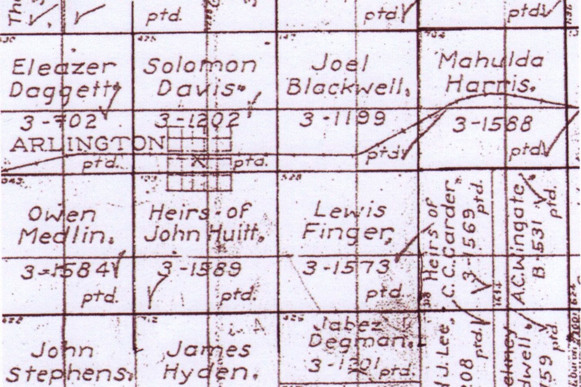
Andrew S. and Maria L. Hayter owned land in the Mahala Harris patent, east of the town site. The length of the right of way in their Mahala Harris tract was about one mile. Following is the text of the deed for the conveyance of that tract to Texas and Pacific Railway:
Deed: A. S. Hayter et ux to Texas and Pacific RR, State of Texas, Tarrant County. Know all men by these presents that we, A. S. Hayter and my wife M. L. Hayter of Tarrant County in consideration of the sum of two hundred and fifty dollars to us paid in hand by the Texas and Pacific Railway, the receipt whereof is hereby acknowledged and further consideration that said Company has built its road over our land situated in the Mahala Harris survey in Tarrant County Texas, we do hereby convey and relinquish and bargain and sell unto said Company the right of way over said lands, the same to extend fifty feet in width on each side of the Center of the trunk of said road together with the use of the stone, lumber, gravel, water etc pertaining to the land so granted and conveyed. To have and to hold the same for the use and purposes aforesaid unto said Company and its Successors forever and we hereby further empower said Company to enter upon and survey and appropriate said land and its appurtenances without further consent or contract on our part, and we hereby relinquish all damages that may have occurred to us by reason of the construction of said road over our said land.
In witness whereof, we have hereunto set out hands this the 7th day of April AD 1877. (signed) A. S. Hayter, M. L. Hayter
Note that this date is nearly a year later than completion of the railroad through the property. The deed was filed by County Clerk J. P. Woods on April 21, 1877.6
Martin V. Thomas owned a small tract in the southwest quadrant of the Solomon Davis patent. The land that he sold to the T & P for right of way was immediately west of the original Arlington town site and about 0.18 mile in length. It was similar to the Hayter deed except that it said "will build its railroad over my lands," was dated June 17, 1876 and was for $35.7 This part of the railroad had just been completed, in that the first train reached the Fort Worth Station on July 19, 1876, part of the way on temporary track. Arista Joyner reports that people in the area of the track were told on July 18 that old work engine No. 20 and a caboose would come through on the next day from where it was stopped near the water tank by the Hayter place. Many people were lined up early the next day to see the train come by and hear the whistle blow.8
T. B. Katner and wife deeded right of way through their land in the Eleazar Daggett headright immediately west of the Solomon Davis patent for sixty dollars "and the further consideration that said company has built its railroad over our lands," signed by Thomas B. Ketner and Martha J. Ketner on November 4, 1876.9
Railroads such as the Union Pacific had established towns at points of their choosing all the way across the west. The Texas and Pacific Railway Company while deciding where to put their rails in Tarrant County ignored Johnson Station in favor of a route with better engineering characteristics. For Arlington they had a station with a long level stretch on the divide between Johnson Creek and Village Creek where it was easy for a train to stop and stand and reached a gentle downhill grade after it started in motion in either direction.
Besides right of way, the railroad bought land for two town sites, Arlington and Handley. By the latter part of 1876 they were busy selling lots in the 160 acre plat now called Old Arlington.
Sources
1. Julia Kathryn Garrett, Fort Worth, A Frontier Triumph, TCU Press, 1966, p. 326.
2. Lisa C. Maxwell, Grand Prairie, Texas, Handbook of Texas Online, s. v. "Grand Prairie."
3. Garrett, op. cit., pp. 58-61.
4. Edna Christman, "History of Arlington", Arlington Journal, October 16, 1925; "Mrs. F. V. Lawrence, Arlington Pioneer Writes of Early Days", Arlington Journal, May 19, 1935; Abstracts of these news articles may be found in "Will E. Keller, Death Notices and Miscellaneous News Items Abstracted from the Arlington Journal", available at the George W. Hawkes Arlington Central Library Genealogy Collection, or accessed online at its web site. Also Eliza Ann Hayter, "Dallas Woman in Reminiscent Vein Tells of Early History of Hayterville and Arlington", Arlington Journal, July 30, 1948. Microfilm of the full article is available.
5. Arlington, Texas Quadrangle Map, U. S. Geological Survey, 1959.
6. Tarrant County Deed Book G, p. 123.
7. Ibid., Book B, pp. 197-8.
8. Arista Joyner, Arlington, Texas, Birthplace of the Metroplex, Arlington Citizen-Journal, 1976, pp. 80-81.
9. Tarrant County Deed Book A, pp. 572-3.