The Original Town of Arlington (Part 1 of 2)
The location of Arlington was chosen by the Texas and Pacific Railway Company for the advantage of the railroad. Railroad officials picked a spot on their line where the center of the town would be ideal for the trains to stop at their depot and terminal buildings and designed the town around it. Newsman Charles Hawkes said that the spot was the highest point on the line between Fort Worth and Texarkana, 605 feet above sea level. He also pointed out that it was about halfway between Dallas, 18 miles east, and Fort Worth, 14 miles west. "Railroad surveyors platted a new town and at first it was to be named Johnson."
The surrounding land had been surveyed by Peters Colony surveyors using the township and range system advocated by Thomas Jefferson and adopted by the U. S. congress in 1785 for new lands in the territories. In this system the basic unit of land is the section, a square tract measuring one mile on each side oriented so that sides are true north-south and east-west. Each section contains 640 acres. Sections were often divided into smaller units of half, quarter, and smaller parts all the way down to the "forty acres and a mule" size farm. This system was applied in north Texas, in contrast to the use of Spanish law procedures in south Texas and the metes and bounds system of the early English colonies in America nearly everywhere else in Texas.
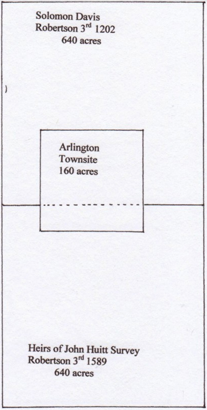
The T & P plat contained 160 acres, a square exactly like a quarter-section, except not located in a corner of the sections already surveyed in the 1850s. As positioned by railroad objectives, it chanced to fall mostly, 73%, in the south half of the Solomon Davis Survey, crossing over into the Heirs of John Huitt Survey further south for the remaining 27% - see plat below.
The plat filed by the "Land Department, T & P RW Co", and signed by W. H. Abrams, is dated March 10, 1878. The T & P land department needed to acquire land for the town, as well as the right of way, from the land owners at the time, seven of them altogether. Without giving complete abstracts of these properties, we will examine a part of their histories, beginning with the patent granted by the State of Texas to Solomon Davis.
The Solomon Davis family was living here to appear on the U.S. census taken October 30, 1850. Solomon was then a 34 year old farmer who was born in Pennsylvania. Wife Mary, born in Missouri, was 22 and their child Alex, born in Texas, was one year old. Solomon had been recorded on the tax roll of Grayson County, Texas in 1840. Solomon claimed 640 acres in the Peters Colony, the appropriate amount for a man and wife, swearing that he had entered the colony prior to July, 1848, had performed all the duties of a citizen and had not previously received any land from the government of Coahuila and Texas, or the Republic of Texas, or the State of Texas. These were the requirements. He received the grant, but he would have to have it resurveyed because there were no maps or field notes on file. The claim, stated to be non-transferable, was signed in Dallas by the Peters Colony land commissioner Thomas William Ward, on May 10, 1850, and recorded as number 566 in Volume 2 of his records. This gave Solomon the right to pick a section of land anywhere in the colony that was previously unclaimed.
The 640 acre tract that Solomon Davis chose was the Arlington location and was surveyed for him on February 26, 1851 by Tarrant County Surveyor A. J. Lee, with Chainmen James Harrison and William Thomas. It was described as 1900 varas on a side, Spanish measure for a mile, and properly described with respect to neighboring patents of James Hyden and William O'Neal, and with corners staked and located with respect to nearby mature trees. Its designation in the Peters Colony layout was Section 27, Township Number 1 South, Range Number 3 West, recorded in Book 1, page 310 of Lee's Field Notes.
Middleton Tate Johnson wrote to the Commissioner of the General Land Office (GLO) in Austin on April 1, 1853 to provide the description of "land that I am entitled to as an assignee of Solomon Davis in accordance with the Supplementary Act passed in July 1853" and to specify that Ward Certificate Number 566 was set in Section 27 Township 1S Range 3W, first base and first meridian of the Texas Emigration and Land Company Survey. The latter is the full name of Peters Colony.
The Patent, Number 652 in Volume 10, State of Texas to Solomon Davis for this 640 acre tract is Abstract 425, Robertson 3rd Class, File Number 1202, attested by S. Crosby, Commissioner of the GLO, and signed by Governor E. M. Pease on November 24, 1854.
Solomon and Mary Davis sold the south half of this land to Middleton Tate Johnson for $160 on March 27, 1855. The south half, which concerns us most for the story of Arlington's beginning, is described in more detail in the deed as "situated and lying in said state and county in the lower cross timbers on waters of the Johnson Station Spring Branch." Both Solomon and Mary signed with their marks.
M. T. Johnson sold this south half in parcels to Lewis Finger and other buyers. Lewis Finger paid $300 for just 80 of the 320 acres in 1860, so it is apparent that land values were rising. Profits were being made.
The southern part of the Arlington townsite lies in the Heirs of John Huitt Patent and has a history that is different from the example of Solomon Davis.
Who were the heirs of John Huitt? And how did their headright become the section of land immediately south of that of Solomon Davis?
John Huitt came to Dallas County, Texas before July of 1843 bringing his family and several negro slaves. The family upon arrival consisted of wife Martha and son Thomas Benton Huitt, who was born about 1837 in Arkansas. Then two daughters Margaret and Irene were born in Dallas County in about 1845 and 1847. Also in the traveling party were John's parents Solomon and Charity Huitt, older brother Rowland Huitt and his family, and John and Martha's oldest son Andrew J. Huitt with a family. All of them were attracted by the available land in the Peters Colony and all qualified for land patents in their names in Dallas and Tarrant Counties.
The John Huitt family settled in the area that is now Carrollton and with the help of negro slave Al planted corn in an open field and made a crop the first year. However, the next year the corn was ruined by buffalo and the family moved to the Cedar Springs area where a cluster of families had already settled. When Dallas County organized on July 13, 1846 John Huitt was elected Sheriff. A neighbor, Samuel G. Newton, served as Deputy.
John Huitt died on January 7, 1848 without a will. Martha Huitt appeared in court on January 17 and requested that she and John's brother Rowland Huitt be appointed co-administrators of the estate, estimated to be worth $2000. Somehow, this did not happen. Instead a succession of administrators took charge as things dragged out over about five years. The widow Martha meanwhile married Anthony Bledsoe on March 11, 1849. Samuel G. Newton, succeeded on February 2, 1851 by L. L. Marshall, were appointed guardians of minor son Thomas B. Huitt.
The estate proved to be more valuable than $2000, as revealed by a series of inventories. It consisted of 150 acres of land bearing a lien to Samuel G. Newton, 58 acres that eventually went to Thomas B. Huitt, livestock, tools for blacksmithing, a variety of credits due the business that John Huitt had shared with Jefferson Tilly, and five negro slaves.
Details of the lives and value of the latter are revealed by court orders permitting their services to be leased for various time periods while the estate was in probate. They were negro man Alson, skilled as a blacksmith, girl Nancy, and negro woman Lucy with two children Mary and Henry. The leases were explicit that these persons were to be treated kindly, adequately clothed during their service, and returned in good health to the administrator at the end of the term of service.
The last asset of the estate to be considered was the headright earned by settlement in Peters Colony. John B. Hibbert, administrator of the estate of John Huitt, made claim for 640 acres for the heirs on March 30, 1850, stating that John Huitt arrived previous to July 1843 in the Colony with wife and children. John Neely Bryan and M. F. Fortner corroborated the statement and Thomas William Ward, Commissioner, entered the grant in his record book on April 1, 1850. The sale of the headright is shown on the same page. J. M. Crockett, "one of the administrators" of the John Huitt estate by order of the county court, sold the headright to Middleton Tate Johnson on August 12, 1852 for $125. So Middleton Tate Johnson chose the location, on open land near his plantation.
The last asset of the estate to be considered was the headright earned by settlement in Peters Colony. John B. Hibbert, administrator of the estate of John Huitt, made claim for 640 acres for the heirs on March 30, 1850, stating that John Huitt arrived previous to July 1843 in the Colony with wife and children. John Neely Bryan and M. F. Fortner corroborated the statement and Thomas William Ward, Commissioner, entered the grant in his record book on April 1, 1850. The sale of the headright is shown on the same page. J. M. Crockett, "one of the administrators" of the John Huitt estate by order of the county court, sold the headright to Middleton Tate Johnson on August 12, 1852 for $125. So Middleton Tate Johnson chose the location, on open land near his plantation.
Deputy Surveyor A. J. Lee, with Chainmen Thom Johnson and Thom Hasty, surveyed Section 34, Township 1S Range 3W for this headright on January 8, 1852. The survey states that the southeast corner is marked by a stake in a mound in the prairie, thus identifying that this corner was in the blackland, while the rest was in the cross timbers. M. T. Johnson sent a letter to the GLO in Austin on April 1, 1853, specifying the accuracy of the location that we know as the John Huitt Survey. Patent No. 782, State of Texas to Heirs of John Huitt (or assigns), was signed by Governor Pease on December 8, 1854.
Middleton Tate Johnson died May 15, 1866. Thereafter, the record shows that "M. T. Johnson (deceased) and wife Vienna Johnson, by Administrators John Peter Smith and M. J. Brinson," sold the north half of the J. Huitt section to S. S. Ramsey on November 1, 1869 by public auction on the courthouse steps for $800. Ramsey subsequently sold 150 acres of this property to W. A. Robinson on January 11, 1871. Ramsey and Robinson would sell portions of these holdings to the T & P for the townsite. See table and map below.
| Grantors to T & P for the Arlington Townsite | |||||
|---|---|---|---|---|---|
| Grantor(s) | Date | Payment | Acres | No/So | East/West |
| Soloman Davis Survey | |||||
| A. Martin V. Thomas | 17 Jun 1876 | $1+ | 13 | 1,940 ft. | 300 ft. |
| B.W.S. Thomas | 3 Nov 1876 | $193.75+ | 43.75 | 1,940 | 983 |
| C. Thomas J. and Julia Ann Heath | 4 Nov 1876 | 14.67 | 1,940 | 330 | |
| D. Josepg Tolliver | 27 Oct 1876 | $206.25 | 14.09 | 620 | 990 |
| E. Lewis Finger | 30 Oct 1876 | $300 | 30 | 1,320 | 990 |
| Heirs of John Huitt Survey | |||||
| F.S.S. Ramsey | 27 Oct 1876 | $184.80 | 18.48 | 700 | 1,145.5 |
| G. William A. Robinson | 17 Jun 1876 | $232.60 | 23.86 | 700 | 1,485 |
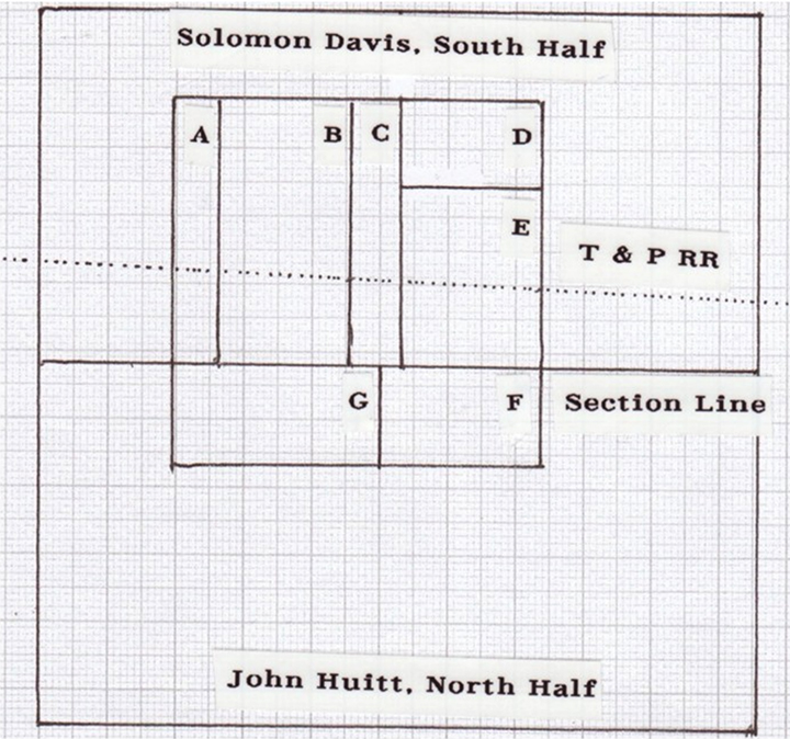
Four of the sellers, the two Thomases, the Heaths, and Joe Tolliver took compensation in land as a part of their deals with the railway company. Finger, Ramsey and Robinson made straight cash sales, all at $10 per acre. Since all of them had remaining parcels immediately outside the town boundary, they could anticipate that they would have an enhanced value as well. The railway surveyors had already marked the boundaries of the town, as evidenced in the deed by Martin V. Thomas, which did not even mention the east-west width of the tract he sold, saying that its boundary goes north with the west line of the W. S. Thomas property to the "North line of a 160 acre tract selected by said company for a depot then west with north line of said 160 acre tract to the northwest corner of same, thence south with west line of said 160 acre townsite."
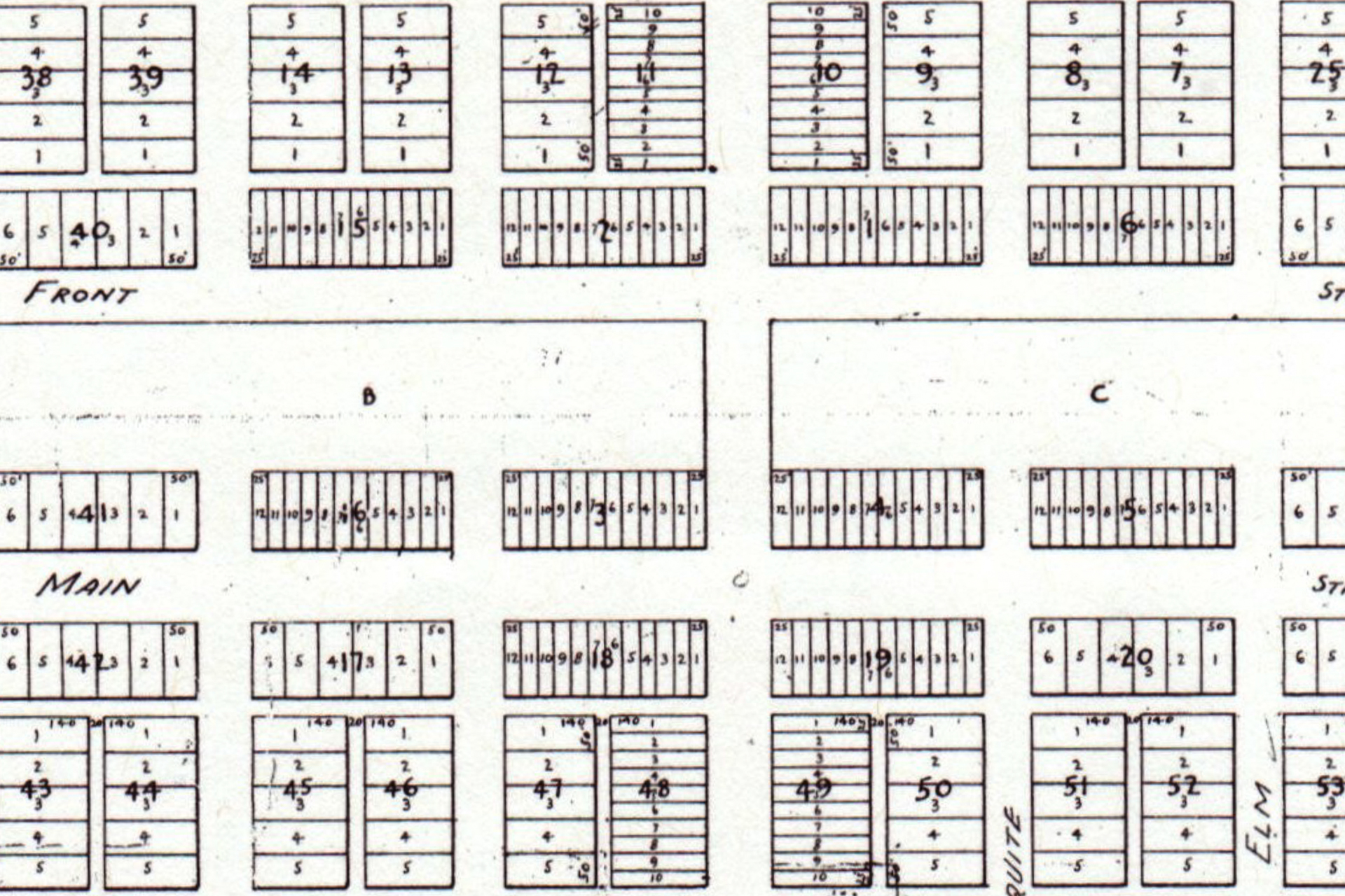
Part 2 of this article includes a plat of the original town of Arlington, 1878, noting several interesting characteristics of the plat, including the fact that there was no Abram Street!